Places to
Explore
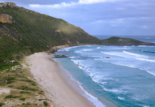
Ancient tingle forests, coastal inlets, world-famous treetop walks — here's what makes riding in Walpole unlike anywhere else on earth.
Giants Trails
Mountain Bike
Network
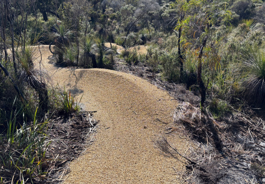
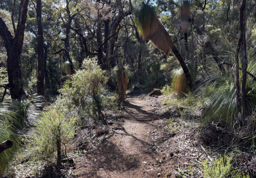
The Giants Trails are a family-friendly network of purpose-built cross-country mountain bike trails in the Walpole-Nornalup National Park. Developed by the Department of Biodiversity, Conservation and Attractions (DBCA) in collaboration with Common Ground Trails and Magic Dirt Trail Works, the network connects the town of Walpole, Nornalup, and the iconic Valley of the Giants Tree Top Walk.
Trails feature flowing singletrack on firm terrain with gentle gradients, minimal elevation changes, and stunning scenery of towering red tingle trees, coastal inlets, and wildlife. Graded green (easy), they're suitable for beginners, families, and casual riders.
The network opened in phases, with full access available from 2025. Trail corridors were carefully selected to minimise impacts on environmental and cultural values.
MTB Loop
Options
From short family circuits to full-day epics — there's a loop to match every rider's ambition and available time.
 Green · Easy
Beginner-friendly circular routes starting from sealed carparks in Walpole or Nornalup. These wind through open tingle woodlands with interpretive signs about local ecology, offering gentle climbs and descents. Ideal for half-day family rides, with picnic spots and views of the Nornalup Inlet. Connects to shared walk/cycle paths for hybrid outings.
 Green · Easy
Flowing trails linking the Valley of the Giants Tree Top Walk to nearby attractions like the Giant Tingle Tree and Hilltop Lookout. Riders pedal among 400-year-old red tingle groves, with boardwalk integrations and minimal roots for smooth pedalling. Great for combining with the Tree Top Walk — add an extra 20–30 min.
 Easy–Moderate
A longer, scenic circuit blending new Giants Trails with sections of the famous Munda Biddi Trail — meaning "path through the forest" in Noongar language. Starts and ends in Walpole, passing Monastery Landing, Sappers Bridge, and Frankland River edges before ascending gently to the Valley of the Giants. Multi-day options with nearby camping.
Don't Miss
These Places
Walk among the canopy of ancient red tingle trees up to 60 metres tall. The ramp system rises to 40 metres above the forest floor — one of WA's most spectacular natural experiences. Entry fees apply.
One of the largest living red tingle trees in the world. Located along the trail network, it serves as a key start/end point for several popular shuttle rides including the Labyrinth and River Run trails.
A panoramic vantage point above the forest and inlet. The start of the popular Rapunzel's Tower trail, which descends to Coal Mine Beach or Walpole. Spectacular views at sunrise and in the golden hour.
A sheltered tidal inlet where the Frankland River meets the Southern Ocean. Several trails offer views across the inlet — peaceful, wildlife-rich, and a perfect lunch stop on a longer ride.
The main trailhead facility featuring a sealed carpark, toilets, and information boards. The purpose-built hub for the Giants Trails network — where most rides begin and end.
Historic bridge over the Frankland River on Brainy Cut Road. The pick-up point for the River Run shuttle — a dramatic riverside finish to one of the network's most adventurous rides.
Pick up trail maps, get local intel, and find out about current trail conditions. Located in the Walpole townsite, it's a great first stop before heading out into the national park.
Excellent interpretive displays on the ecology of the tingle forest, local Noongar culture, and the history of the region. Worth 30 minutes before or after your ride for deeper context on what you're riding through.
Make the most of your time in the forest
- Best season: September–November for wildflowers in bloom along the trail corridors
- Phone reception: Limited — 4G on the Telstra network only. Download offline maps before you ride
- Ride with a buddy: Trails are remote and long sections are isolated from vehicle access
- Stay on trail: The ecosystem is fragile — stick to marked paths to protect ancient root systems
- Brake check: For downhill rides especially, ensure brakes are in perfect working order before starting
- Entry fees: Apply for Walpole-Nornalup National Park — check the DBCA website for current rates
Everything you need to plan your visit
- Rate Road Trailhead: New sealed carpark, toilets, and information boards. Main hub for the Giants Trails network
- Walpole Visitor Centre: Trail maps, local information, and ranger advice on current conditions
- Valley of the Giants Discovery Centre: Interpretive displays, toilets, and café on site
- Camping: Multi-day riders can utilise existing Bibbulmun Track huts for overnight adventures
- Broader network: Munda Biddi Trail Map 8 (Walpole to Denmark, ~154 km) passes through for longer touring options
- Harder rides: For more technical terrain, consider extending to Denmark's coastal tracks
For the latest trail maps, conditions, and updates visit the DBCA Giants Trails project page or browse the full network on Trails WA. Both sites carry current access information and downloadable maps for offline use.